
September 6, 2010
My friend Brennen Wysong had presented today’s run to me as what he termed “a noble challenge.” He is an accomplished ultra-runner who I had met years ago in the early miles of the 2005 Escarpment Trail Run. After I told Brennen about my plans to run all the trails of Harriman State Park, he suggested running the Suffern-Bear Mountain Trail (SBM) end to end. A quick check of the map showed that this trail traversed virtually the entire length of the park from north to south. It looked gargantuan compared to any of the runs that I had done to date, and upon searching out this trail on the NY/NJ Trail Conference website, I learned that it comprised a grand total of 23.5 miles. As I thought about it, I realized that this was exactly 1/10th of all of the park’s trail miles, and the prospect of knocking off such a big chunk of the project in one fell swoop was very appealing. 🙂
And so it was that I announced my plans to my friends, hoping to solicit a few crazies into running it with me. The run was to take place on Labor Day, and based on some feedback that Brennen had given me, I made two decisions:
1) Run it in the southerly direction. I had wanted to run north to avoid having the sun in my face in the afternoon, but Brennen said that it would probably be better to get the bigger climbs out of the way early so as to avoid having to run them in the latter stages on very tired legs.
2) Start very early. My guess was that it would take 6 to 6.5 hours. Brennen explained that it would be more like 7 to 7.5 hours. He turned out to be dead on, so I was quite happy that we’d scheduled a 6:30am start.
After some back and forth email with my running friends, it became that I would run the entire trail with my friend Todd Van Sickle. I had done some semi-long trail runs with Todd before (2.5 to 3 hours), and we were good running partners, so I knew this would be a great day for both of us. And joining us at approximately the midpoint would be my friends Gary Arne and Joe Falcon. Gary had run trails before, and is a strong distance runner (he’s run about 15 marathons), but he wasn’t ready to commit to the entire 23.5 miles at this point. My friend Joe, on the other hand, had never run a mountain trail before, so the 12 miles or so that he would run with me would be an experience-and-a-half for him!
I set out at a little after 5:00am (with my sweetheart Catherine) to go and meet Todd. The plan was to park his car at the finish in Suffern (Catherine and I had scouted out the parking place yesterday), drive to the midpoint to place our drop bags, and then go up to the start at Bear Mountain. We arrived at the Bear Mountain Inn a little before 6:30am. Some gnarly dude with a sleeping bag in his hand approached us and asked if we knew where to buy a trail map. I mean, really!! So I pulled out my map, showed him where he could pick up a trail that went up the mountain, and then turned and focused back on our business. Catherine took a nice picture of Todd and I with Bear Mountain as the backdrop, wished us a great run, and drove off to do her own workout in the park; a 50-mile bike ride and a one hour swim in Lake Tiorati.

Starting out from Bear Mountain
And so, Todd and I began our search for the start of the trail. A review of the map indicated that the SBM trail was common with the Appalachian Trail for the first 1/4 mile or so. Finally finding the trailhead for the AT, we started up the mountain. And this is where our trouble began. We never saw a yellow trail marker for the SBM, and kept going unwittingly up and up the mountain. By the time we reached a fire road and had another look at the map, we realized that we must have gone way too far, and after a brief discussion, decided to start back down to find out where we had gone astray. To my embarrassment, we came to find out that the SBM trail actually began all the way back at the bottom of the mountain, and in fact, shared no common ground with the AT. Forty minutes of time and toil had been dedicated to this boondoggle, for which I was responsible. Rats!!
But anyway, it felt good to finally be on the trail and on our way. 🙂 The very first thing we did was climb, and this would be only the first of many. Traveling across the south face of Bear Mountain, Todd and I swiftly hit the first of what would be just three road crossings in today’s adventure. After reaching the other side of Seven Lakes Drive, we descended for the next half mile, and reached the crossing of the 1777W Trail and the Doodletown Bridle Path. The Doodletown story is an interesting one. It was a small hamlet nestled here in the northern part of the park, only sparsely populated until World War I, after which it grew from 75 inhabitants to almost 300 by 1945. But by 1962, the park had bought virtually all of the homes there, relegating Doodletown to a ghost town, and sealing its story in the annals of history.

the trail going up West Mountain
Moving past Doodletown, we began our climb up West Mountain. This was our second major climb, and as it turned out, our most difficult one of the day. About eight hundred feet we ascended over a mere 3/4 of a mile, and the terrain was especially rocky as well. Needless to say, most of this section was traversed by walking, and we were delighted to finally reach the top and regather ourselves. After having done that, we had opportunity to enjoy a nice run across the top of the ridge, with our first scenic viewpoints! The first vista provided a wonderful view of the Hudson River, signs of civilization in Rockland County, and also (and to our surprise) a startling view of the New York City skyline some 45 miles away! Todd and I were doing some picture taking, and since he was the one posing against the backdrop and I was taking the picture, I was the first to see the cityscape from atop this rocky crag. After snapping a pic, I said to him “OK, now turn around to your left.” He was duly impressed with this view. 🙂 We traded places, he snapping a pic of me this time, and then we packed up and got moving again.

We went down though a valley, up a ridge, down the other side, and then over a small rise called Horn Hill before finally reaching the junction of the 1779 Trail. From there in the middle of a very dry swamp (this has been a very dry summer, for sure), we would proceed to make a pair of climbs – first, over a rise called The Pines, and then up to the top of Pingyp Mountain. The summit of Pingyp had some spectacular views of the Palisades Parkway below us, and knowing that our route would take us across the Palisades very soon, I knew that the descent would be a fairly steep one. That turned out to be a major understatement. In fact, the slope was so steep in places that if you weren’t very careful, you could probably fall to your death! Todd was ahead of me, and at one point he turned around and said “Do we need rope to get down this?!” It was comically dangerous, and my nerves were on high alert as we continued down this nasty mountain face.
Upon reaching the bottom (and with a big sigh of relief), we crossed the Parkway and did our best to follow the trail markings that were on the guardrails alongside the road. Finally ducking back into the woods, we began the last major climb before reaching the halfway point. This time, it was a long, sustained two-part climb up Pound Swamp Mountain and Irish Mountain. Seven hundred and fifty feet we would scale over the next mile or so, and knowing that we still had a long day ahead of us, we quickly reverted to “walk mode.” As we made our ascent up Pound Swamp, I pulled out my phone and texted my friend Gary, letting him know that we were perhaps 30-40 mins away from the meet point on Gate Hill Rd. He replied letting me know that he was on his way. It would be nice to see he and Joe upon our arrival at their cars. But with a bit more work still to do, Todd and I forged ahead.
On the trail map, I had seen an interesting landmark at the top of Irish Mountain called the Irish Potato. Presuming that it was some kind of potato-shaped rock, I put Todd on the lookout for it. And as we neared the top of the mountain, we spied many large rocks that we thought might be the potato. But upon arriving at a very large stone sitting alone in the middle of the woods, there was no mistake that we had finally reached the famed monolith. 😉 
Taking a moment to get a pic of this oddity on the trail, Todd and I anxiously and gratefully made our way down the final slope to the halfway point, and within minutes, we had emerged from the woods onto Gate Hill Rd to see Gary and Joe both pulling into the parking area. Talk about timing!
So for the first half of the run, including the boondoggle up Bear Mountain at the beginning, Todd and I had been out there for 3 hours and 49 minutes. A lot of ground covered, for sure, but still such a long way to go!
 Dreams In Action – Marshall Ulrich
 Lisa Smith-Batchen's Blog
 Notes on a Running Life – Douglas Hegley
 rundangerously
 The Long Brown Path
 NYCRUNS
 Philip Melillo Health & Fitness
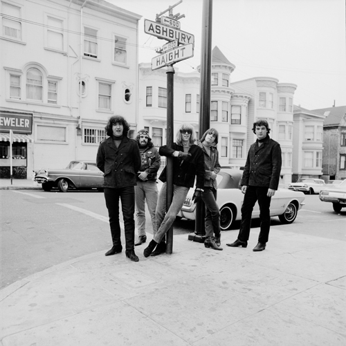


Todd thanks for writing these articles…they are quite enjoyable! I plan on running my first trails in Harriman tomorrow!
Red Cross–>Beech Trail–>Long Path Loop from Lake Skannatati
As an aside, I was wondering what type of shoe you wear on the trails? I currently have 2-year old Merrell’s which are in much need of replacing. Any suggestions would be great.
Hi Kevin, and thanks so much for reading and commenting on my blog. 🙂 I have run that same grouping of trail that you will be running tomorrow. The Red Cross trail is steep and rugged on both sides of Seven Lakes Drive at that point. The Long Path and Beech Trail however are both relatively flat in that area, and you can actually open it up aand do some running! Also, I ran there in the evening, as I recall, and finishing in the twilght was quite a delight.
As to your query about shoes, there are lots of good ones out there. You obviously know that Merrell is a quality brand, and if you’ve found that the model you’re running in works for you, then try to stick with it. I have been running in Adidas Supernova (the trail version) for a couple of seasons now, and I will probably switch from them with my next purchase, as they don’t hold well to my feet the way a proper trail shoe should. I feel that’s the most important quality of a good trail shoe – that it is snnug to your foot, from top to bottom, and particularly the instep. It will keep you fairly safe from the “toe jam” that the technical trails in Harriman State Park can make you prone to.
Enjoy the run tomorrow, Kevin, and again, thanks for tuning in to my blog. I will continue to post entries as I move toward completion of my project. And join me for a run if you can. I will be better about letting everyone know my schedule.
Tod. Saturday morning was amazing…51 degrees and sunny skies. Despite the chill in the air, it was quickly forgotten as we ascended the brutal first portion of the Red Cross trail. Despite some trail flooding due to the significant rains last week, all in all the run was quite enjoyable.
The only problem is that I live in NYC and have limited access to a car, limited meaning only when I can drag one of my friends out for the day. I know that there is some access to the trails via bus and rail, but I’m not sure how effect these options are? I guess I have to research more. Anyway, I am certaintly game for a group run, so please keep me updated. Otherwise, thanks again for the great blog!
PS: after extensive research, I ended up buying the Montrail Rockridge. They should be in next week.
Great news, Kevin! 🙂 You’re right, there is access to the trails via train and bus, but it is limited to just a few access points, so can be difficult for sure.
Although I live here in the Lower Hudson Valley, I am in NYC somewhat often, and run in Central Park and along the East River. It might be fun to do a “trail” run together in C.P. If you want to, you can email me at todjen@optonline.net, and I can let you know the next time I am planning to be in NYC. Conversely, I can also let you know when I am running up here, and perhaps I can pick you up from the train or bus to run.
Todd…busy week at the office so I wasn’t able to write! Anyway, my friend enjoyed last week so much that I easily convinced him to go for another. Thankfully his wife and my girlfriend were on board with the plan. Once again, we were rewarded with another beautiful day. After much deliberation during the week, we chose the Silvermine Loop (Menomine–>AT–>Long Path–>Menomine).
Armed with my new Montrail’s, we hit the trails. I think I always forget how difficult the hills really are, but i guess that’s what keeps us coming back in the end! The run was difficult and rocky, with lots of walking up the steep sections and even more ankle twisting throughout. Overall though the sneakers performed well and we were pretty tired at the end.
That leads me to my next point. I would be up for running with you one of these days but it seems that you are a much more accomplished runner than me. What is the pace that you typically run? Just curious as I wouldn’t want to slow anyone down?
As for central park, there are indeed some limited trails if you are interested.
Yes Kevin, I know that loop you ran. The Menomine Trail is pretty technical on both the northern and southern sides of Silvermine Lake. The Long Path section you ran is especially nice – there are some views across the valley of the Arden House along that stretch. AM glad you all had fun!
As to me and the pace that I run, I would tell you that pace is a relative term on the trails. So much so that I don’t really keep track of pace all that much. I can tell you that when I am out on a running excursion in the park, I cover anywhere between 3.5 and 4.5 miles per hour. It depends an awful lot on the terrain. I don’t own a GPS, so my mileage is usually a guesstimate. That being said, I don’t know if it precludes our running trails together. I hope not. I am generally trying to get out for a longish run every other weekend. Those weekends are usually the 2nd and 4th weekends of the month.
Let me know when you’ll be free and perhaps we can give it a go. 🙂
Check that – I am typically free the 1st and 3rd weekends of the month.
Todd…based on what you said it looks like we sould have no problem running together, as long as you dont go for a 20 miler! I do have a garmin watch which i have used on both Harriman runs and the average moving pace was about 11 minute miles, with some in the 8’s and some much higher depending on the section and if we are walking a lot.
The most i have done on the trails was actually this Monday (Columbus Day), when I ran 12.8 miles. I took the bus from NYC up route 8w in NJ to the NY/NJ border. I then ran down the Long Path to the beginning right near the GWB. Total moving time was a little under 2 hours with another 10 minutes of breaktime additional. This of course was easy terrain after the first few miles.
My girfriend has mandated some quality time the next few weeks, but maybe we can shoot for the first weekend of next month? Any idea of what you still need to run? It would be fun to do some research.
OK Todd, time to visit the Irish Potato!!! When can we do it?